The villages of North Pelion
North Pelion
The villages
Between the peaks of Mt Pelion and Mt Kissavos streches a large semi-mountainous area, with an amorphous yet complex terrain. The natural resources of the area, agricultural, forest and water, are limited, scattered and hidden within the landscape. Anchored in these conditions, villages, monasteries and rural clusters were historically small, few and isolated.
The geography of the villages of Northern Pelion reflects the stiftness of a wild and astrigent natural frame, where a human history of centuries wea able just to add a few minor scratches.
Keramidi

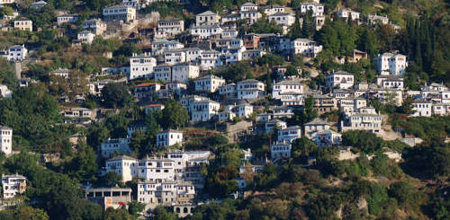
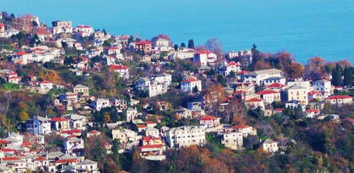
Keramidi is located at an elevation of 350m. It is a picturesque village, with scenic alleys and old house of traditional architecture. The village is built is 16th century, in this remote and hidden location, in order to be hidden from the pirates and other invaders. It is the main village of the broader area and it has 700 inhabitants. This number almost doubles during the summer months, due to the pleasantly cool climate and the close distance to the beautiful beaches. The view to the Aegean Sea and Kassandra peninsula of Chalkidiki can inspire even the most demanding travelers.
In the past, Keramidi used to be the commercial and administrative hub of North Pelion. Today, Keramidi along with Veneto, form one of the four communities of Magnesia district which are not integrated in the Volos municipality administrative unit. The other three communities are are Anavra, Makrinitsa and Trikeri.
The center of the settlement of Keramidi extends evenly around the stone-built church of St. George, a large basilica constructed in 1787. Around the church, the visitor can admire the remarkable tile-paved town square, knows as Alonaki and the nearby old school.
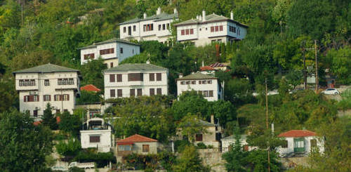
In the charming stone alleys one can find many small local businesses with traditional products, as well as taverns and kafeneia (coffee houses), while it’s worth visiting the Folklore museum of Keramidi, very close to the town square. The core of the settlement is formed by two-storey houses, built at the end of the 19th century.
There are three options for those who want to spend time at the seaside: the beach of Kamari, Agrielia, where there is also a small fishing spot and the more popular beach Ai Giannis.
Veneto

Veneto is located SE of Keramidi, at an altitude of 320 meters and is one of the most remote villages of North Pelion. The settlement spreads on a sunny balcony at the base of dense forests of oak, chestnut, walnut and plane trees.
The largest part of the settlement consists of newly built two-storey houses, most of which are inhabited only in the summer. The old physiognomy of the settlement is preserved in the small village square, the old fountains and the winding streets.
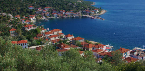
From Veneto, the access to the coast is done either via the Koulouri bay, which served as the port of the village, or via the beach Petromelisso. On the rocks of its wild coast open sea caves and other karst formations, which are the subject of exploration of organized coastal excursions starting from Agiokambos, Chorefto or Damouchari.
Kamari
Kamari is a seaside hamlet located at the east coast. Being for long time the seaport for the much more populated Keramidi, Kamari provides some tourism-related services during the summer months.
Kato Kerasia

Kato Kerasia is a relatively large village, at the western foot of Mt Pelion and at the exit of the Kerasiotis torrent (elevation 130 m). It is the mother settlement of the hamlet Ano Kerasia (elevation 650 m), which was destroyed during the 2WW and is today ruined and deserted.
Kato Kerasia hosts 291 inhabitants, according to 2011 census. Geographically and economically, Kerasia is more related to the area of Lake Karla and the village of Kanalia, than to Mt Pelion villages.
It seems that the village was formed in the 17th century, when the zone around Lake Karla received waves of seasonal and permanent installations from Pindos mountain range. The location of Kerasia points to its role as the gate to the labyrinthine terrain between Karla and Makrinitsa and as a reception area for the farmers of North Pelion who were looking for occasional employment around Lake Karla.
The settlement is today more oriented to the west and the main productive field remains the agricultural sector. Recently, the "Center for Research and Protection of the native Orchid in North Pelion" was established.
Kanalia
The village Kanalia occupies a smooth outcrop east of Lake Karla. As is the case with many other areas adjacent to shallow lakes, the place has been inhabited since the Neolithic years..
The name of the village testifies to its close relationship with Karla lake, to which Kanalia owe both the prolonged period of stability that characterizes their history, and the main resource on which their prosperity was based: fish production. In their heyday, Kanalia had three fish ladders and "Karliotika fishes" were sold all over Thessaly, even in Volos.
The drainage of the lake, which coincided with the period of urbanization of the Greek countryside, sent a large part of the population to Velestino and Larissa. During a period of declining importance of the value of the agricultural product, Kanalia managed to maintain a privileged position, thanks to the production of local almond varieties.
Today, Kanalia, a village of 1,000 inhabitants, maintains its role in the local social system, mainly thanks to its educational infrastructure. The settlement hosts the headquarters of the Management Body of the Lake Karla, as well as the Museum of Lake Culture, two organizations that focus on the ecological importance and history of the reborn lake.
Text and photos: T. Adamakopoulos
topoguide Greece
GUIDES TO MT PELION

North Pelion topoguide is available for Android devices along with dozens of guides of other regions of Greece, within the hiking application topoguide Greece. Get North Pelion topoguide as an in-app purchase through the application.
North Pelion topoguide is also available for iOS (iPhone και iPad) devices within the hiking application Topoguide Greece. Get the Northern Pelion topoguide as an in-app purchase via the application.
North Pelion is a member of the Central Greece topoguides group.
It is very interesting that topoguide Greece has the ability to simultaneously display many areas, thus allowing the overall view of the detailed map of the whole of Mt Pelion and the easy alternation of the routes, the Points Of Interest and the dozens of pages of the guide with the countless photos.