Stemnitsa-Dimitsana
Menalon Trail
Stemnitsa-Dimitsana

The chapel of Metamorfosi Sotiros,
a bit higher Prodromou monastery
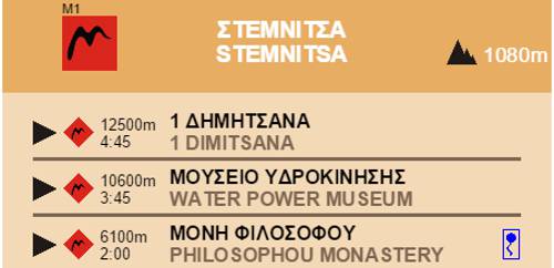
The first section is the Stemnitsa-Dimitsana trail, running along the Lousios valley. The trail starts form Stemnitsa, the village of traditional goldsmiths, point of convergence of many other routes and trails. From the main square of Stemnitsa, follow the densely waymarked red_romvos_menalo cobbled path that heads out of the village toward Prodromos Monastery.

Click to enlarge
Just before St. Nikolaos, a sign post directs you to the first earth path, the old mule track to the Prodromos Monastery. The path crosses an old farmland area that used to be an important winemaking region and its centre was the Kamari fountain. On your left there are great panoramic views of Megalopoli.
Upon intersecting the asphalt road, follow it for a while, until reaching the church of the Transfiguration of Christ where you can take water from the fountain and rest while admiring the view of the Lousios gorge before going into the paved path that leads to the Prodromos Monastery. After visiting the monastery, nested under an impressive boulder and cross the Lousios river using the concrete Philosophou Bridge, at the place where the riverbed forms an impressive narrowing.

The old Philosophou monastery

Philosophou monastery

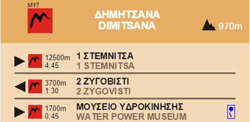
Dimitsana

Elevation profile

Distribution over elevation zones and trail type
Text and photos by T. Adamakopoulos

topoguide Greece
Menalon Trail topoguide

The digital field guide Menalon Trail topoguide is available for Android devices as an in-app purchase within the application topoguide Greece. Menalon Trail is a member of the Long Trails group.
The digital field guide Menalon Trail topoguide is also available for iOS (iPhone and iPad) devices as an in-app purchase within the application Topoguide Greece. There also, Menalon Trail is a member of the Long Trails group.
Menalon Trail topoguide offers active guidance along the trail, as well as an extented guidebook on the geography, the nature and the history of the area.