Pouri-Makrinitsa via the Pourianos Stavros summit
North Pelion
Pouri-Makrinitsa via the Pourianos Stavros summit

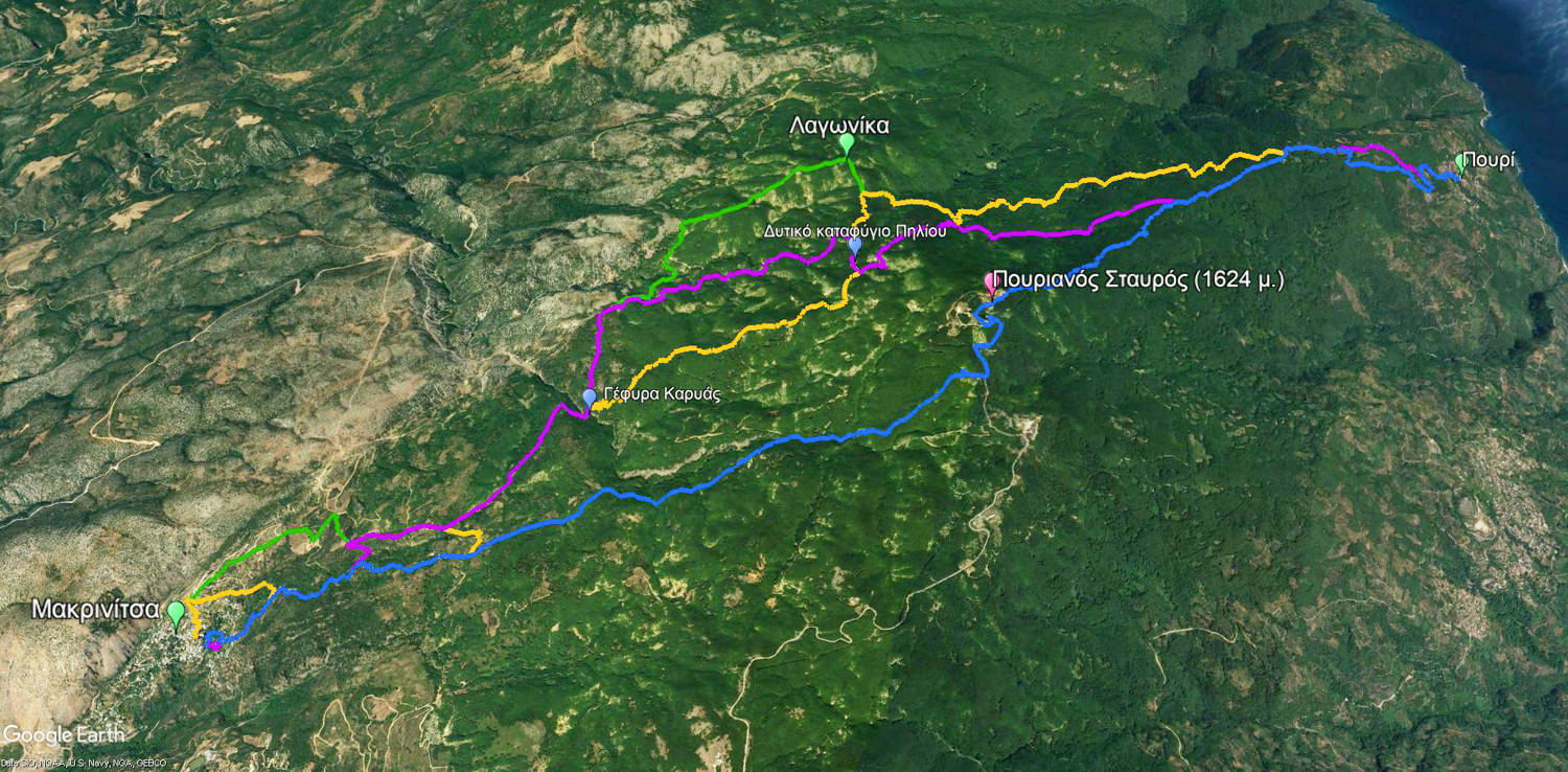
Blue: Pouri-Makrinitsa via the Pourianos Stavros summit
Purple: Makrinitsa-Pouri via the Western bivouac
Green: Makrinitsa-Pouri via the Lagonika
Orange: Makrinitsa-Pouri via the Kapsales
Click to enlarge
Blue: Pouri-Makrinitsa via the Pourianos Stavros summit
Purple: Makrinitsa-Pouri via the Western bivouac
Green: Makrinitsa-Pouri via the Lagonika
Orange: Makrinitsa-Pouri via the Kapsales
The hiking route Pouri – Makrinitsa crosses the highest peak of Pelion, known as Pourianos Stavros. The route is the shortest but the most difficult among the four connections between Makrinitsa and the remote settlement of Pouri.

Profitis Ilias chapel
Set off from the town square of Pouri early in the morning aiming to Makrinitsa. At the beginning, follow the alleys of the settlement, until the end of the village.
Then, cross a field where chestnut trees are cultivated. Go steadily uphill on the dirt road and finally pass in front of the Profitis Ilias chapel. Very soon, cross another well-maintained chestnut plantation and continue across apple orchards. Next, the trail goes through a natural chestnut forest, following the red marks on the trees. Pass by the chapel of Agia Marina and follow the concrete ditch.

Agia Marina chapel

Kotroni springs: a small dam for water intake

The Trano Isoma plateau
Text and photos: T. Adamakopoulos
Marking-Warnings
The route is 17.2 km long and crosses desert forested areas at a relatively high altitude (1600m elevation). Adequate supplies and good fitness condition are required.
In winter, most of the route is covered by a thick layer of snow.

topoguide Greece
GUIDES TO MT PELION

North Pelion topoguide is available for Android devices along with dozens of guides of other regions of Greece, within the hiking application topoguide Greece. Get North Pelion topoguide as an in-app purchase through the application.
North Pelion topoguide is also available for iOS (iPhone και iPad) devices within the hiking application Topoguide Greece. Get the North Pelion topoguide as an in-app purchase via the application.
North Pelion is a member of the Central Greece topoguides group.
It is very interesting that topoguide Greece has the ability to simultaneously display many areas, thus allowing the overall view of the detailed map of the whole of Mt Pelion and the easy alternation of the routes, the Points Of Interest and the dozens of pages of the guide with the countless photos.

